

What Is It?
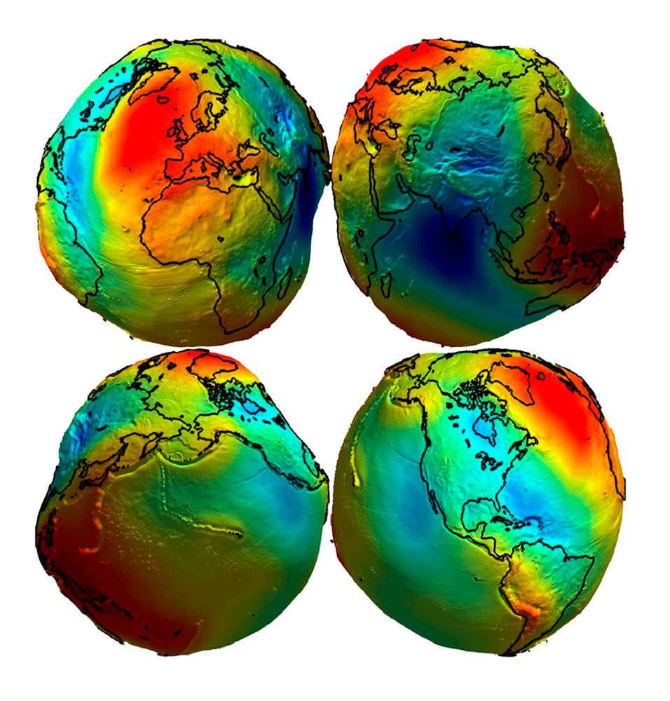
A geoid is a model that represents the mean sea level across a surface, extended under the continents. It’s used as a method to define physical shape by considering variations in gravitational fields. Unlike ellipsoidal models – used for mapping and navigation – a geoid reflects the complex, downward acceleration exerted on the Earth's surface. This model serves as a reference surface from which elevations and depths can be measured.
Geoid Modeling Process
Creating accurate geoid models involves a complex process that integrates data from various sources and sophisticated mathematical techniques. Below, I provide a basic outline of the process used to create geoid models, from data collection to model refinement.
Data Collection
A. Gravitational Data:
Satellites equipped with gravimeters, such as those from the GRACE (Gravity Recovery and Climate Experiment) mission, measure variations in Earth's gravity from space. These measurements provide global data on gravitational anomalies.
Gravimeters on the ground collect local gravity data, filling gaps left by satellite measurements. These are often used to refine and validate satellite data.
B. Topographic and Bathymetric Data:
Detailed topographic data from sources like LiDAR, digital elevation models (DEMs), and ground surveys provide information on Earth's surface features.
Bathymetric data from sonar surveys map the ocean floor. Variations in seafloor depth affect local gravity.
Data Integration
A. Gravity Field Processing:
Gravity data from various sources are processed to determine gravitational anomalies, which are deviations from a reference gravitational field (usually a spherical or ellipsoidal model).
Satellite and ground-based data is integrated to create a gravity field model. This involves harmonizing measurements from different sources and correcting for observational errors.
B. Topographic and Bathymetric Corrections:
Topographic and bathymetric data is used to adjust gravity measurements for the effects of elevation and seafloor depth.
Model Calculation
A. Mathematical Modeling:
The Earth's gravitational field is expanded into spherical harmonics, mathematical functions that describe shape and gravitational variations in a series of terms.
The geoid undulation, which represents the difference between the geoid and an ellipsoidal reference surface, is calculated. This involves solving equations that incorporate gravity anomalies and the Earth's gravitational field expansion.
B. Numerical Techniques:
The raw data is interpolated to create a continuous surface, and filtering techniques are applied to remove noise and smooth the model.
The model is optimized to fit the available data, adjusting parameters to fit between the observed gravity anomalies and the calculated geoid surface.
Validation & Refinement
A. Cross-Validation:
The model is compared with independent measurements, such as those from precise leveling surveys and altimetry data, to assess accuracy.
Statistical analysis is performed to identify and correct errors or discrepancies in the model. This may involve revising data processing methods or refining mathematical models.
B. Model Updates:
As new data become available, the model is updated. This includes incorporating new satellite observations, updated topographic and bathymetric data, and advances in mathematical techniques.
Application & Dissemination
A. Model Usage:
The model is used for elevation measurements, sea level monitoring, and satellite orbit determination.
The model is often made available to the public and researchers through online databases and software tools, facilitating its use in various scientific and engineering applications.
Conclusion
As outlined above, the geoid is a model that comes into existence via mathematics. It begins as real measurements from land surveying, downward acceleration, and other data points. It’s then created by expansion, harmonizing, and various mathematical methods all being compared to a reference ellipsoid. It’s a complex process that results in a model that’s not intended to determine the exact figure of Earth.